
Trace a St. Louis Street by Address
The address workflow is strongest when it follows the county's handoff from location to record. Start with the property address, not a presumed household name. The Revenue search and GIS Property Lookup identify the parcel, then the deed book and page can route the search to the Recorder. A voter list or a historical directory may add a dated name at that address, but neither converts the parcel owner field into proof of present residence. Keep every result in its own role and date.
- Search the address in the St. Louis County Real Estate Search. Save the locator, property address, legal description, subdivision, and any deed book/page shown.
- Open the same location in the GIS Property Lookup. Compare the property address with the separate owner-mailing fields and read the municipality.
- Use the Recorder handoff for the instrument trail. Capture the document role, grantor, grantee, recording date, legal description, and book/page or document number.
- For a lawful civic or historical purpose, use the state registration lookup to confirm supplied information, or review the county's EIS list-request rules before seeking an allowed list.
- When the question concerns an earlier household, search the reverse directory by address and pair its printed year with the volume and page.
That sequence makes a street-by-street search a record trail, rather than a claim that every name found at an address describes the same person at the same time.
St. Louis Street Directory Record Layers
Address-keyed sources answer different questions. The county's current property tools are useful for identifying a parcel and its administrative fields. Recorded instruments establish a conveyance, while a directory preserves a dated printed address. The table separates those record roles and identifies the access route when an online screen is incomplete.
| Address Record | Custodian | Useful Street Detail | Access Route |
|---|---|---|---|
| Real Estate Search | County Revenue | Current owner field, assessment, situs address, subdivision | Free online search |
| GIS parcel layer | GIS Service Center | Geometry, property ZIP, deed book/page, jurisdiction fields | Free map and parcel layer |
| Recorded instruments | Recorder of Deeds | Grantor, grantee, instrument and legal description | Recorder route or deed-copy request |
| Accela records | County permit system | Construction, occupancy, license, water/sewer categories | Citizen Access; screen fields vary |
| Voter EIS list | Board of Elections | Address components, precinct/split, registration and election fields | Purpose-limited request form |
| Reverse directories | St. Louis County Library | Listed household or business at an address, year and page | Digitized, microfilm, scanner, or staff help |
The same street name can cross municipalities. On a boundary-area street, retain the property ZIP, MUNICIPALITY, ward, council district, school district, fire district, and legal description as separate facts. A mailing label alone cannot settle which local custodian holds a related permit or record.
Note: A current parcel record and a printed directory entry describe different record dates and should never be treated as one live household list.
Search St. Louis Property Address Fields
The County Revenue form provides a disciplined first pass for an address search. Select Property Address, enter the number and street name, then add the directional and suffix when the address uses them. If no parcel appears, test an abbreviated suffix or directional separately before deciding the county has no matching property record. The search also offers locator, name, and subdivision routes, but a street task should begin with the property-address controls.
| Form field | Type | Use in an address search |
|---|---|---|
| Property Address | Route selector | Activates the address controls. |
| Street number | Text, tboxAddrNum | Enter the known property number. |
| Street name | Text, tboxStreet | Enter the road name without guessing the suffix. |
| Direction | Select, ddboxDir | Use only when the address includes a directional. |
| Street suffix | Select, ddboxSuffix | Choose the documented street type when needed. |
| Search | Button | Runs the selected search route. |
For a locator search, the live validation calls for no spaces and an alphabetic third character. The observed pattern is two digits, a letter, and further digits. Preserve the locator exactly as returned, because it connects the assessor result to the GIS parcel layer and supports a more precise request to county staff.
The County Real Estate Search shows the address-search choices used in this workflow.
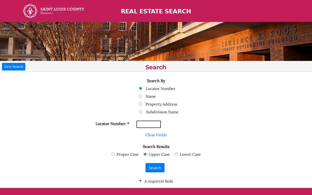
Use the screen as a starting point, then read the returned property and ownership fields as county parcel data, not as a present-occupancy statement.
Walk a St. Louis Street in GIS
The GIS app adds the map work that the assessor form does not. Search by address, locator, or a last-name-first owner query, open the Results tab, and select the parcel. At a close map extent, the attribute table can filter by the visible extent or an expression, zoom to selected records, and export selected attributes. Shift-select makes it possible to examine a bounded run of parcels without guessing which numbers are adjacent.
Save the locator, PROP_ADD, PROP_ZIP, legal description, DEEDBKPG, and municipality with the source date. The app identifies separate owner-mailing fields such as OWN_ADD and OWN_ZIP. That separation is a useful guard against mistaking correspondence information for the property address.
- Parcel
- A mapped tax-property unit with a locator and boundary geometry.
- Situs address
- The address of the property itself, distinct from an owner mailing address.
- Plat
- A map or recorded layout that identifies lots, blocks, streets, and subdivisions.
- Criss-cross directory
- A reverse directory organized by address so a reader can work from a street to listed names.
The GIS Service Center warns that published data can be inaccurate. Confirm an important ownership, legal-description, or boundary conclusion with the appropriate county office rather than relying on an export or map image alone.
Follow St. Louis Deeds by Address
A current parcel card is only the handoff to the deed chain. Use DEEDBKPG if it appears, then search the Recorder of Deeds route by the current grantee or owner string and by the legal description. Each instrument can point backward through a grantor or prior grantee. Record the recording date, instrument type, book/page or document number, legal description, and any image or copy status before moving to the next link.
The direct Recorder search did not expose a stable live field layout during research, so its online start year and image coverage are not assumed here. When the route does not produce a usable record, use the county's deed-copy request route or ask the Recorder about public-terminal access. The documented copy schedule is $2 for the first page, $1 for each additional page, and $1 for certification, plus the listed postage tiers. Confirm the current form before payment or mailing.
The Recorder search route is the official handoff for an instrument found through a parcel search.
A deed names parties to a recorded transfer. It does not, by itself, identify every person who occupied the property.
Recover St. Louis Street Households
A street-first search becomes especially helpful when a family researcher knows an address but not a surname. St. Louis County Library directories can preserve a dated household or business listing by address, and the reverse section is documented in the back of the 1922 city directory. Search the address section first, then check the alphabetical section for the printed entry. Write down the volume, year, page, and whether the result came from a reverse or alphabetical listing.
Paper volumes may be fragile and may not be photocopied. The library offers microfilm and digital-reader, scanner, flash-drive, and staff-lookup paths. Use a plat or atlas with the directory year before translating an old house number into a current parcel. For the directory collections themselves, the St. Louis Directory Book keeps the focus on the historical shelves rather than the current address chain.
Note: A reverse-directory listing is evidence that a name was printed at an address for that volume year, not proof of a modern resident.
Read St. Louis Street Boundaries
St. Louis County's record geography has a lasting city and county split. St. Louis City separated from the county in 1876, and county offices moved to Clayton after the county-seat decision in 1877. For an older street record, the date and original place label determine whether a City of St. Louis custodian, a county office, the library, or the State Archives is the next stop.
The 1878 Pitzman's Atlas and the 1909 county plat book are local tools for comparing earlier lots and street layouts with modern GIS. Municipalities also incorporated, annexed, or changed labels over time. Record both the historic label and the present GIS municipality, rather than replacing one with the other. This is particularly important where a St. Louis mailing label extends across several incorporated places.
Use St. Louis Permit Address Clues
County Accela Citizen Access exposes categories for construction permits, occupancy permits, licenses, and water or sewer programs. A public entry can be a useful address clue when it supplies an application or permit number and a date. It is not title evidence, and the field layout and result coverage were not exposed during research. Keep the exact public record type rather than expanding a permit into a claim about a household.
For municipal code, occupancy, or permit material, use the municipality identified in GIS. There is no single countywide municipal-record index for every address. A focused request that names the address, record type, time range, preferred format, and fee-estimate request is more workable than a request for every item connected to a street.
Use St. Louis Voter Street Data
Missouri's public voter-registration lookup is an identity-verification tool, not an open street list. It requires the registered first and last name, date of birth, last four digits of Social Security number, and county. The county Board of Elections EIS form is the separate list-request route. Its output options include street components, ZIP, precinct or split, registration date, last vote date, and election date, but a request must meet the form's rules.
The EIS form was revised January 15, 2025 and offers countywide, district, and municipal requests with stated fees. It also cites RSMo §115.158.6, which limits master-list use. Treat voter data as a purpose-limited civic record and do not treat a mailing or registration address as conclusive proof of current residence.
Limits of St. Louis Street Records
Street records cannot supply a universal current roster. Parcel ownership, owner mailing information, recorded transfers, directory listings, voter records, and permits are separate record types with different dates and access limits. Protected voter entries, Safe at Home substitute addresses, sealed court material, motor-vehicle information, utility customers, and non-public household details stay outside this address workflow.
Lawful use. Use St. Louis address records for a personal, civic, property, or family-history purpose. Do not assemble record fragments to follow, threaten, harass, or intimidate another person.
When a needed county record is not available on a public screen, Missouri Sunshine Law requests can name the custodian, record type, address or name, date range, preferred format, and request for a fee estimate. The Attorney General's guidance allows fees tied to copies and appropriate staff time. A denied or delayed request can be narrowed by asking for the cited exception and segregable open portions.
Note: Preserve the official URL, access date, locator, book/page, and municipality with every street-directory result so the underlying record can be checked later.